Planet Earth is getting a digital twin.
A pair of friends who met during high school in an online forum are now using their PhDs in computer science to pioneer artificial intelligence (AI) techniques that will allow them to create an exact digital replica of the world — one that adds deep and rich layers of detail and nuance to the traditional online mapping experience.
This digital twin will allow people to play video games in real-world settings, safely simulate self-driving car technology on virtual streets, and visualize architectural plans for new buildings.
“As an AI company, we teach computers to parse out and understand every detail of what exists in the real world, and turn it into rich digital environments,” said Christopher Mitchell, co-founder and chief technology officer of Geopipe.
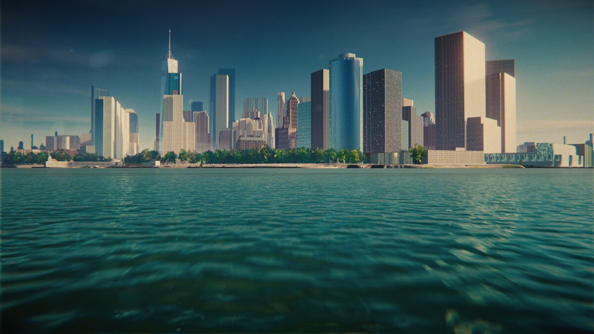
To date, Geopipe has released digital twins — 3D models of a space — of New York City, Boston, San Francisco, and a few other cities. The company is focusing on a limited set of cities as it refines its AI models to create high-resolution digital replicas. From there, the company plans to create digital twins of all the world’s major cities and then everywhere in between — from small towns and mountains to the world’s beaches, forests, and deserts.
Today, the most common approach to create digital twins of cities and landscapes is photogrammetry, which extracts three-dimensional information about objects, structures, and terrain from photographs and other imagery. Well-known online virtual globes that allow users to find their neighborhoods and other points of interest are typically made with this approach.

While these tools are popular, their shortcomings become clear when people zoom in for close-up views, noted Mitchell. “Trees are these weird green melted blobs. Sometimes the walls of houses melt into the ground. If there are shadows, they are baked in. You can never change the season or time of day. There’s no intelligence or metadata of what’s actually in the world, and as a result you could never walk around at human scale in this world and say, ‘Oh yeah, this is believable,’” he said.
Geopipe’s mission is to address those shortcomings. Dozens of games built by indie developers during two recent Geopipe-sponsored hackathons or “game jams” illustrate the potential of their approach. Developers used Geopipe digital twins to rapidly build games set in New York City over a variety of genres, from fast-paced racing games to more relaxed “cozy games”. Other early adopters of the technology come from the simulation, defense, architecture, engineering, and construction fields.
“When you’re designing a new thing, it’s really helpful to be able to show what it looks like in the context of the existing surroundings,” said Thomas Dickerson, co-founder and chief science officer of Geopipe. To do this, users download a copy of the respective area, digitally delete the existing building, and insert renderings of the replacements.
Geopipe aims to license digital twins to video game developers, simulation builders, municipalities, architectural firms, and anyone else who wants access to a slice of the virtual Earth.
“We really see ourselves disrupting across multiple industry segments,” noted chief executive officer Ben Jones. “If you think about any one city or the planet overall as a digital asset that can be used in various workflows, whether it’s a game or simulation, once we generate that asset, it can be licensed over and over again.”
Gaming roots
Mitchell, who grew up in New York City, and Dickerson, who grew up in rural Vermont, became fast friends when they met in an online forum dedicated to hacking graphing calculators to play classic arcade games and access the internet. They also shared a parallel passion for hobby game development.
Their interest in digital twin technology grew from graduate school side projects. Mitchell, who earned a PhD in computer science at New York University, tried to build a 1:1 copy of New York City in Minecraft. Dickerson, who earned his computer science PhD at Brown University in Providence, RI, tried to simplify models of real-world landmarks into virtual LEGO architecture sets.
To succeed, they both needed robust 3D models.
“We quickly found that there was no way we could get digital twins,” Mitchell said. “We certainly didn’t have the time to build them by hand, which is how most people do it today for doing applications like video game development — they have to manually place every tree, every building, every road, and every lamppost. So we started looking at how we could teach computers to understand the world and do it for us.”
Teaching computers to understand the world
Geopipe draws on partners’ datasets with a range of sensor data — including photos taken from the ground and air, maps, and laser scans — to train AI models. The models identify what’s what in the world — evergreen trees, sidewalks, brick buildings, double-hung windows — and then learn the recipes, or instructions, for how to digitally re-create them.
The process is called inverse procedural modeling, akin to the opposite of following the step-by-step instructions to build a house out of LEGO bricks, Dickerson explained. In this case, the house is already built; the AI is trained to identify a house as a house, then break it down into individual bricks and write the step-by-step instructions to re-create it.
Once the model is trained, it can be deployed on layers of sensor data from an unknown neighborhood or city block, then identify what’s in the world and follow the recipes to generate a digital twin. When the model encounters data about objects that are unknown to it, the scientists add this data to the training dataset and improve the model.

“We pay a lot of the costs upfront when we do the learning process, and then we can solve each individual instance much more quickly at runtime,” Dickerson said.
An advantage to Geopipe’s approach, noted Mitchell, is the ability to take updated data from even a single source, such as a new aerial photo, and generate new copies of the world with changes such as a new building that went up downtown or a new road out in the suburbs.
What’s more, Mitchell added, the recipes are designed to make the digital twins interactive.
“You can open the doors, look out of the windows, and light up the street lights. If it rains, the bricks will look a certain way. If you want to make it post-apocalyptic, you might put vines on the outside or destroy the top third of the building,” he said. “You can then easily populate these environments with cars, people, and fine details.”
Computationally heavy
Creating digital twins with AI is computationally heavy, and, to that end, Geopipe deploys its geographic pipeline on Amazon Web Services (AWS). Mitchell and Dickerson both studied distributed computing systems in graduate school and have applied that approach to Geopipe’s workload, parallelizing it across multiple servers to process the world rapidly and accurately.
“By scaling up the number of servers we use to process the world, we can update it really quickly,” Mitchell said. “So not only can we create areas that were just too slow or too expensive to build digital models of before, we can now also keep them up to date at a fast cadence using tools like AWS.”
The team thinks creating a digital twin of the whole Earth will require a handful of years. By the end of 2023, they hope to have a dozen cities and then expand from there.
Constantly updated digital twins, noted Jones, the Geopipe CEO, should have commercial appeal.
“Ultimately, you’ll have this living asset that’s constantly updating,” Jones said. “That’s the ideal world, and we’re going to get there as the data continues to improve, the graphics continue to improve, and the AI continues to improve.”


